
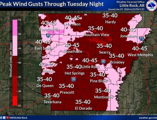
Strong and gusty southerly winds will begin to impact the state
today [March 29, 2022], with sustained winds approaching 15 to 20 mph, and gusts up
to 25 to 30 mph at most locations.

Widespread showers and thunderstorms will be seen Wednesday as a
strong storm system moves across Arkansas. A few strong to severe
storms are possible, especially over about the eastern half of the
state. Any severe storms will be capable of producing damaging
wind gusts in excess of 60 MPH. A brief tornado or two could occur
as well. There is a lesser threat of large hail.

Any stronger storms will also be capable of producing heavy
rainfall, which could cause some localized flash flooding issues. At
this time, it appears severe weather will be most likely further
south and east of Arkansas.

Windy conditions are expected on Wednesday through Wednesday
Evening. Winds of 30 to 40 MPH are expected, especially over the
higher terrain of the Ozark and Ouachita Mountains, and over eastern
Arkansas. Gusts over 40 MPH will be possible as well. The gusty
winds will create hazardous conditions on area bodies of water, and
could make driving more difficult or potentially hazardous,
especially for higher profile vehicles.

With any heavy rainfall that occurs in the coming days, there may be
enough to keep portions of the Black, Cache, Ouachita, and lower
White Rivers elevated. This is where minor flooding is ongoing, and
will continue in the coming days.

(Source:  National Weather Service Little Rock)

