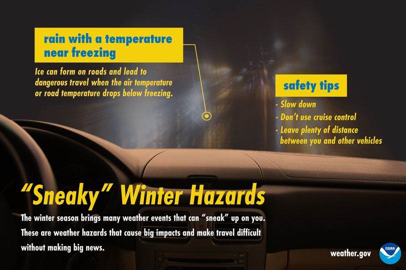
According to the National Weather Service Little Rock office...A few slick roadways possible this morning...
Light rain with temperatures in the upper 20s/lower 30s has caused a few slick spots to develop around central and southern Arkansas. Roadways impacted are typically elevated such as bridges/overpasses. I-440 which is largely elevated has developed a few slick spots as of 4 AM.
Be safe everyone!

The National Weather Service in Little Rock has released this Special Weather Statement on Feb. 26 at 3:32 a.m for counties including Fulton, Izard and Sharp:

"...Light wintry precip possible this morning and tonight...

A couple of rounds of light wintry precipitation are possible
across the state this morning and Saturday night into early Sunday
morning. Little to no accumulation of freezing rain or sleet is
expected.

During these two rounds of precipitation, a few elevated surfaces
could briefly become slick but widespread impacts are not
expected."

On the afternoon of Feb. 25, the following Hazardous Weather Outlook involving a large portion of Arkansas as well as Fulton, Izard and Sharp counties was issued:

"DAY ONE...Today and Tonight [Feb. 25, 2022]

A quick shot of mixed precipitation including freezing rain and
sleet may be seen across central and southern Arkansas late Friday
night into early Saturday morning. A glazing of ice accumulation
is possible, particularly on overpasses and bridges.


DAYS TWO THROUGH SEVEN...Saturday Through Thursday [Feb. 26-Mar. 3, 2022]

Saturday night into Sunday morning, a quick round of light snow will
be possible across northern central Arkansas and the higher
terrain of the Ozark Mountains. A transition zone of
rain/sleet/snow will also be possible along and near the I-40/I-30 corridor.
Accumulations are expected to remain minimal with around a
dusting or glaze possible."
