After several inches of rainfall early Monday, here is what we’re expecting through the rest of the week, as the unsettled pattern continues to bring additional rain our way. The trend continues to focus much of the activity across the west.

We continue to be concerned with heavy rain potential over the next few days.
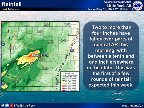
Situation Overview• Several rounds of showers and thunderstorms will continue to affect the state through at least Wednesday Night• With multiple rounds of rainfall expected, rainfall amounts could be heavy, especially over western into central Arkansas. This will add to already saturated ground from rainfall during the day Monday. • Additional rainfall of three to four inches could occur over western portions of the state, with localized amounts in excess of four inches possible. • At this time, it appears the threat for heaviest rainfall will be on Tuesday into Wednesday.
Some areas of west central into central Arkansas have seen several inches of rain in the last 24 hours. Additional rainfall will only increase the likelihood of flash flooding, especially over western and west central Arkansas. Flood Watches and Flash Flood Watches have been issued for southwest into central Arkansas beginning Tuesday morning and continuing through Wednesday Night. Primary Concerns• Flash flooding, primarily in areas that have already seen heavy rainfall.• Repeated rounds of storms over the same areas (training) will increase the likelihood of flash flooding.• Rises on area rivers and streams are possible. These would be most likely on the Ouachita, Saline, and Little Missouri Rivers. Minor rises are possible on the Arkansas River later in the week, and the Petit Jean and Fourche Lafave could be affected as well • Heaviest, most widespread rain will be Tuesday, Tuesday Night and Wednesday.
Meteorologists at your Arkansas NWS offices will continue to monitor the situation, and forecasts will be updated and likely be adjusted to reflect the latest data. The Evening Shift, National Weather Service Little Rock, Arkansas
