A Storm Surge Warning is in effect for…
- * East of Rockefeller Wildlife Refuge Louisiana to the Mississippi/Alabama state line
- * Vermilion Bay, Lake Borgne, Lake Pontchartrain, and Lake MaurepasA Hurricane Warning is in effect for…
- * Intracoastal City Louisiana to the Mouth of the Pearl River
- * Lake Pontchartrain, Lake Maurepas, and Metropolitan New Orleans
A Storm Surge Watch is in effect for…
- * Sabine Pass to Rockefeller Wildlife Refuge Louisiana
- * Mobile BayA Hurricane Watch is in effect for…
- * Cameron Louisiana to west of Intracoastal City Louisiana
- * Mouth of the Pearl River to the Mississippi/Alabama state liner
A Tropical Storm Warning is in effect for…
- * Cameron Louisiana to west of Intracoastal City Louisiana
- * Mouth of the Pearl River to the Mississippi/Alabama state line
A Tropical Storm Watch is in effect for…
- * Mississippi/Alabama state line to the Alabama/Florida state line
Hurricane conditions are expected in the hurricane warning area along the northern Gulf coast beginning Sunday with tropical storm conditions expected to begin by late Saturday night or early Sunday morning. These conditions will spread inland over portions of Louisiana and Mississippi Sunday night and Monday. Gusty winds are possible over portions of western Cuba and the Florida Keys this morning.
Interests elsewhere along the northern U.S. Gulf coast should monitor the progress of this system.
For storm information specific to your area in the United States, including possible inland watches and warnings, please monitor products issued by your local National Weather Service forecast office. www.weather.gov
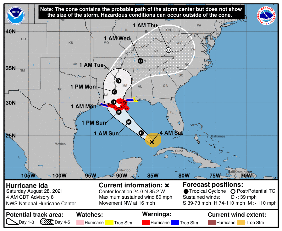
At 4 a.m. CDT, the center of Hurricane Ida was located over the Gulf of Mexico about 510 miles (825 km) southeast of New Orleans, Louisiana.
Ida is moving toward the northwest near 16 mph (26 km/h) and this general motion should continue through late Sunday or early Monday. A slower northward motion is forecast on Monday. On the forecast track, the center of Ida will move over the southeastern Gulf of Mexico today and over the north central Gulf of Mexico on Sunday. Ida is then expected to make landfall along the U.S. northern Gulf coast within the hurricane warning area by late Sunday or early Monday, then move through portions of Louisiana or western Mississippi later on Monday.
Maximum sustained winds are near 80 mph (130 km/h) with higher gusts. Hurricane-force winds extend outward up to 25 miles (35 km) from the center and tropical-storm-force winds extend outward up to 115 miles (185 km). The estimated minimum central pressure is 987 mb (29.15 inches). Rapid strengthening is forecast during the next 24 to 36 hours and Ida is expected to be an extremely dangerous major hurricane when it approaches the northern Gulf coast on Sunday. Weakening is expected after Ida makes landfall.
The combination of a dangerous storm surge and the tide will cause normally dry areas near the coast to be flooded by rising waters moving inland from the shoreline. The water could reach the following heights above ground somewhere in the indicated areas if the peak surge occurs at the time of high tide:- Morgan City, LA to Mouth of the Mississippi River…10-15 ft- Mouth of the Mississippi River to Ocean Springs, MS including Lake Borgne…7-11 ft- Intracoastal City, LA to Morgan City, LA including Vermilion Bay…6-9 ft- Ocean Springs, MS to MS/AL state line…4-7 ft- Lake Pontchartrain…4-7 ft- Lake Maurepas…3-5 ft- Pecan Island, LA to Intracoastal City, LA…3-5 ft- MS/AL state line to AL/FL state line including Mobile Bay…2-4 ftSabine Pass to Pecan Island, LA…2-4 ft.
Overtopping of local levees outside of the Hurricane and Storm Damage Risk Reduction System is possible where local inundation values may be higher than those shown above.
Ida will continue to lift north of Cuba this morning bringing an additional 2 to 4 inches of rain with isolated maximum amounts of 6 inches across western Cuba through today. These rainfall amounts may produce flash floods and mudslides. As Ida moves into the Louisiana coast late Sunday, total rainfall accumulations of 8 to 16 inches with isolated maximum amounts of 20 inches are possible across southeast Louisiana and southern Mississippi through Monday. This is likely to result in significant flash and riverine flooding impacts.The next advisory will be issued by NHC at 10 a.m. CDT with an intermediate advisory at 7 a.m. CDT – www.hurricanes.gov
