HOT OFF THE PRESSES! It looks like Old Man Winter will pay us another visit, this time around mid to late week. A few key details:
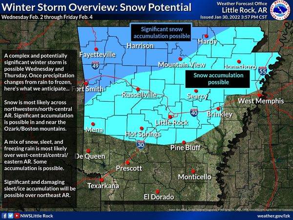
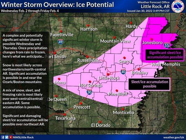
![]() Significant accumulations of snow, sleet, and freezing rain are all on the table at this time (as of now: highest risk of sig snow over northwest/north-central AR, highest chance of sig ice over northeast AR).
Significant accumulations of snow, sleet, and freezing rain are all on the table at this time (as of now: highest risk of sig snow over northwest/north-central AR, highest chance of sig ice over northeast AR).
![]() What will begin as rain on Tuesday will gradually transition to a **messy wintry mix** with lots of back-and-forth between precip types. This makes the forecast even more challenging with these transitions likely wreaking havoc on accumulation forecasts.
What will begin as rain on Tuesday will gradually transition to a **messy wintry mix** with lots of back-and-forth between precip types. This makes the forecast even more challenging with these transitions likely wreaking havoc on accumulation forecasts.
![]() There are still several forecast cycles (aka, when a new forecast is produced by the NWS) between now and then. This forecast **WILL CHANGE WITH TIME** and following subsequent updates from trusted sources will be key for staying informed. This is really, really far from being a slam dunk scenario.
There are still several forecast cycles (aka, when a new forecast is produced by the NWS) between now and then. This forecast **WILL CHANGE WITH TIME** and following subsequent updates from trusted sources will be key for staying informed. This is really, really far from being a slam dunk scenario.
![]() Take time now to think through your winter preparedness plan! In addition to wintry weather, a frigid Arctic air mass will settle in by Thursday into Friday. Low temperatures in the single digits and wind chill temperatures below zero are possible over northwestern AR. This will not be a repeat of last February’s Arctic outbreak and winter storms, but will be dangerous nonetheless.
Take time now to think through your winter preparedness plan! In addition to wintry weather, a frigid Arctic air mass will settle in by Thursday into Friday. Low temperatures in the single digits and wind chill temperatures below zero are possible over northwestern AR. This will not be a repeat of last February’s Arctic outbreak and winter storms, but will be dangerous nonetheless.


